
Hanga Roa topographic map
Click on the map to display elevation.
About this map
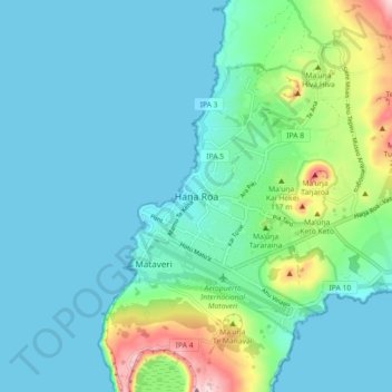
Name: Hanga Roa topographic map, elevation, terrain.
Average elevation: 59 m
Minimum elevation: 0 m
Maximum elevation: 316 m
Other topographic maps
Click on a map to view its topography, its elevation and its terrain.
Easter Island
Chile > Valparaiso Region > Easter Island Province > Easter Island
The current Polynesian name of the island, Rapa Nui ("Big Rapa"), was coined after the slave raids of the early 1860s, and refers to the island's topographic resemblance to the island of Rapa in the Bass Islands of the Austral Islands group. However, Norwegian ethnographer Thor Heyerdahl argued that Rapa was…
Average elevation: 48 m
Easter Island
Chile > Valparaiso Region > Easter Island Province > Easter Island
The current Polynesian name of the island, Rapa Nui ("Big Rapa"), was coined after the slave raids of the early 1860s, and refers to the island's topographic resemblance to the island of Rapa in the Bass Islands of the Austral Islands group. Norwegian ethnographer Thor Heyerdahl argued that Rapa was Easter…
Average elevation: 48 m