
Woodmore topographic map
Interactive map
Click on the map to display elevation.
About this map
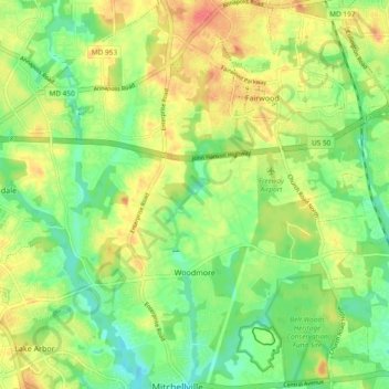
Name: Woodmore topographic map, elevation, terrain.
Average elevation: 45 m
Minimum elevation: 22 m
Maximum elevation: 72 m
Other topographic maps
Click on a map to view its topography, its elevation and its terrain.
Jacksonville
États-Unis > Maryland > Jacksonville
Jacksonville, Comté de Baltimore, Maryland, 21131, États-Unis
Average elevation: 170 m
Stanbrook
États-Unis > Maryland > Stanbrook
Stanbrook, Comté de Baltimore, Maryland, 21222, États-Unis
Average elevation: 8 m
Odenton
États-Unis > Maryland > Odenton
Odenton, Anne Arundel County, Maryland, 21113, États-Unis
Average elevation: 49 m
Bethesda
États-Unis > Maryland > Bethesda
Bethesda, Montgomery County, Maryland, 22814, États-Unis
Average elevation: 86 m
Manahan Ranch Estates
États-Unis > Maryland > Manahan Ranch Estates
Manahan Ranch Estates, Frederick County, Maryland, 21780, États-Unis
Average elevation: 397 m
Providence
États-Unis > Maryland > Providence
Providence, Comté de Cecil, Maryland, 21916, États-Unis
Average elevation: 98 m