Geolocate

Alvalade topographic map

Click on the map to display elevation.

About this map

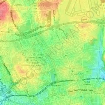
Name: Alvalade topographic map, elevation, terrain.

Location: Alvalade, Lisbon, Portugal (38.74463 -9.16978 38.76307 -9.12853)

Average elevation: 88 m

Minimum elevation: 30 m

Maximum elevation: 117 m

Other topographic maps

Click on a map to view its topography, its elevation and its terrain.

São Jorge Castle

Portugal > Lisbon > Lisbon > Madalena

Average elevation: 34 m

Madalena

Portugal > Lisbon > Lisbon

Average elevation: 23 m

Parque Laudato Si

Portugal > Lisbon > Lisbon

Average elevation: 98 m

Gear up for your next adventure:

🧢Waterproof Hiking Hats - Keep the rain off your face while studying topographic maps
🧴Sport Sunscreen Sticks - High-protection sunblock that won't run into your eyes on the trail
📷Outdoor Action Cameras - Cameras designed for hiking and adventure
👟Heavy Duty Boot Laces - Always carry a spare for your hiking footwear
🥾Hiking Boot Waterproofing Wax - Maintain the lifespan of your leather trekking boots

As an Amazon Associate, this site earns from qualifying purchases at no extra cost to you.