
Thank you for supporting this site ❤️
Make a donation
Make a donation
Gear up for your next adventure:
As an Amazon Associate, this site earns from qualifying purchases at no extra cost to you.
Asahidake topographic map
Click on the map to display elevation.
Thank you for supporting this site ❤️
Make a donation
Make a donation
Gear up for your next adventure:
As an Amazon Associate, this site earns from qualifying purchases at no extra cost to you.
About this map
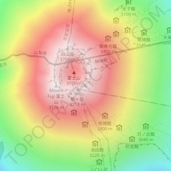
Name: Asahidake topographic map, elevation, terrain.
Location: Asahidake, Oyama, Sunto County, Shizuoka Prefecture, Japan (35.36064 138.73302 35.36074 138.73312)
Average elevation: 3,250 m
Minimum elevation: 2,646 m
Maximum elevation: 3,757 m
Thank you for supporting this site ❤️
Make a donation
Make a donation
Gear up for your next adventure:
As an Amazon Associate, this site earns from qualifying purchases at no extra cost to you.