Geolocate

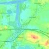
Fockbek topographic map

Click on the map to display elevation.

About this map

Name: Fockbek topographic map, elevation, terrain.

Location: Fockbek, Kreis Rendsburg-Eckernförde, Schleswig-Holstein, 24787, Germany (54.27697 9.54287 54.34419 9.62798)

Average elevation: 10 m

Minimum elevation: -3 m

Maximum elevation: 24 m

Other topographic maps

Click on a map to view its topography, its elevation and its terrain.

Gear up for your next adventure:

🎒Hiking Daypacks (20L) - Compact backpacks for day trips and technical mountain ascents
🛰️Satellite Messengers - Emergency communication devices for areas without mobile signal
🥤Collapsible Water Bottles - Save space in your rucksack as you consume your water
🚲Bikepacking Frame Bags - Storage for tools and navigation gear on long off-road rides
🔥Reusable Hand Warmers - Maintain dexterity in your fingers for precise map handling

As an Amazon Associate, this site earns from qualifying purchases at no extra cost to you.