
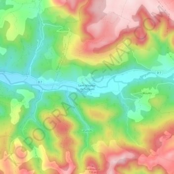
Saint-Maurice-de-Sorgues topographic map
Interactive map
Click on the map to display elevation.
About this map
Name: Saint-Maurice-de-Sorgues topographic map, elevation, terrain.
Average elevation: 582 m
Minimum elevation: 425 m
Maximum elevation: 760 m
Other topographic maps
Click on a map to view its topography, its elevation and its terrain.
Moulès
France > Occitanie > Aveyron > Fondamente
Moulès, Fondamente, Millau, Aveyron, Occitanie, France métropolitaine, 12540, France
Average elevation: 597 m
Pas Farrat
France > Occitanie > Aveyron > Fondamente
Pas Farrat, Fondamente, Millau, Aveyron, Occitanie, France métropolitaine, 12540, France
Average elevation: 710 m
Les Cluges
France > Occitanie > Aveyron > Fondamente
Les Cluges, Fondamente, Millau, Aveyron, Occitanie, France métropolitaine, 12540, France
Average elevation: 621 m
Pas Farrat
France > Occitanie > Aveyron > Fondamente
Pas Farrat, Fondamente, Millau, Aveyron, Occitanie, France métropolitaine, 12540, France
Average elevation: 710 m