
Make a donation
Gear up for your next adventure:
As an Amazon Associate, this site earns from qualifying purchases at no extra cost to you.
Saltoro Kangri topographic map
Click on the map to display elevation.
Make a donation
Gear up for your next adventure:
As an Amazon Associate, this site earns from qualifying purchases at no extra cost to you.
Saltoro Kangri
The mountain underwent reconnaissance by Fanny Bullock Workman and her husband in the year 1911-12. The initial endeavor to conquer the peak, which was then denoted as "Peak 36," took place in 1935, led by a British expedition headed by James Waller and John Hunt. Hunt's involvement in the expedition had been suggested by the Himalayan Club in Calcutta. Among the expedition's members were Rowland Brotherhood and Dr. Steward Carslaw, accompanied by two Sherpas named Palden and Dawa Thondup. Their approach to the mountain commenced from the Likah Glacier, with the objective of ascending the South East ridge. They successfully established a final camp on June 19th, yet their altitude estimation proved to be inaccurate. An attempt to reach the summit the following day, amidst worsening weather conditions, was thwarted as they were required to ascend an additional 3500 feet. Hunt and Brotherhood managed to reach an elevation of 24,500 feet but were compelled to turn around.
Make a donation
Gear up for your next adventure:
As an Amazon Associate, this site earns from qualifying purchases at no extra cost to you.
About this map
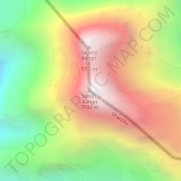
Name: Saltoro Kangri topographic map, elevation, terrain.
Average elevation: 6,651 m
Minimum elevation: 5,580 m
Maximum elevation: 7,689 m
Make a donation
Gear up for your next adventure:
As an Amazon Associate, this site earns from qualifying purchases at no extra cost to you.
Other topographic maps
Click on a map to view its topography, its elevation and its terrain.