
Poplar Creek topographic map
Interactive map
Click on the map to display elevation.
About this map
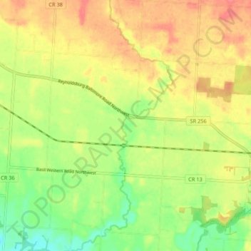
Name: Poplar Creek topographic map, elevation, terrain.
Location: Poplar Creek, Fairfield County, Ohio, 43112, United States (39.82574 -82.68223 39.88871 -82.65061)
Average elevation: 268 m
Minimum elevation: 236 m
Maximum elevation: 296 m
Other topographic maps
Click on a map to view its topography, its elevation and its terrain.
Rising Park
United States > Ohio > Fairfield County > Lancaster
Rising Park, Lancaster, Pleasant Township, Fairfield County, Ohio, United States
Average elevation: 274 m
Baltimore
United States > Ohio > Fairfield County
Baltimore, Liberty Township, Fairfield County, Ohio, 43105, United States
Average elevation: 267 m
Whites
United States > Ohio > Fairfield County > Lancaster > Whites
Whites, Lancaster, Fairfield County, Ohio, 43130, United States
Average elevation: 262 m
Lancaster
United States > Ohio > Fairfield County > Lancaster
Lancaster, Fairfield County, Ohio, 43130, United States
Average elevation: 283 m
Lockville
United States > Ohio > Fairfield County > Lockville
Lockville, Fairfield County, Ohio, 43112, United States
Average elevation: 251 m