
Pookode topographic map
Interactive map
Click on the map to display elevation.
About this map
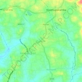
Name: Pookode topographic map, elevation, terrain.
Location: Pookode, Thalassery, Kannur district, Kerala, 670691, India (11.79454 75.53768 11.83454 75.57768)
Average elevation: 28 m
Minimum elevation: 5 m
Maximum elevation: 70 m
Other topographic maps
Click on a map to view its topography, its elevation and its terrain.
Kolayad
India > Kerala > Thalassery
Kolayad, Thalassery, Kannur District, Kerala, India
Average elevation: 81 m
Kaitheri
India > Kerala > Thalassery
Kaitheri, Thalassery, Kannur district, Kerala, 670701, India
Average elevation: 63 m
Kadavathur
India > Kerala > Thalassery > Peringatoor
Kadavathur, Peringatoor, Thalassery, Kannur district, Kerala, 673505, India
Average elevation: 18 m
Kottayam
India > Kerala > Thalassery > Kottayam Poyil
Kottayam, Kottayam Poyil, Thalassery, Kannur district, Kerala, India
Average elevation: 28 m
Thalassery
India > Kerala > Thalassery > Thalassery
Thalassery, Kannur district, Kerala, 670100, India
Average elevation: 9 m
Kodiyeri
India > Kerala > Thalassery > Kodiyeri
Kodiyeri, Thalassery, Kannur district, Kerala, 670102, India
Average elevation: 16 m
Edayar
India > Kerala > Thalassery > Kolayad
Edayar, Kolayad, Thalassery, Kannur district, Kerala, India
Average elevation: 70 m