Geolocate

Highland topographic map

Click on the map to display elevation.

About this map

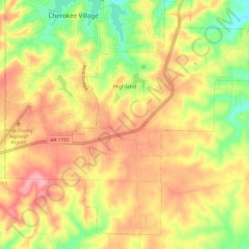
Name: Highland topographic map, elevation, terrain.

Location: Highland, Sharp County, Arkansas, United States (36.23402 -91.56596 36.29620 -91.47898)

Average elevation: 194 m

Minimum elevation: 130 m

Maximum elevation: 245 m

Other topographic maps

Click on a map to view its topography, its elevation and its terrain.

Poughkeepsie

United States > Arkansas > Sharp County

Average elevation: 143 m

Gear up for your next adventure:

👖Packable Overtrousers - Quick-deploy rain protection for legs in sudden storms
🔋Rechargeable Batteries - Eco-friendly power for headlamps and older GPS units
📱Rugged Phone Cases - Heavy-duty protection for smartphones used as secondary GPS tools
🌂Windproof Trekking Umbrellas - Surprising but effective rain protection on low-wind trails
🔦LED Camping Lanterns - Illumination for reading maps inside your tent at night

As an Amazon Associate, this site earns from qualifying purchases at no extra cost to you.