
Make a donation
Gear up for your next adventure:
As an Amazon Associate, this site earns from qualifying purchases at no extra cost to you.
Snow Hill topographic map
Click on the map to display elevation.
Make a donation
Gear up for your next adventure:
As an Amazon Associate, this site earns from qualifying purchases at no extra cost to you.
Snow Hill
Snow Hill was founded in 1686 in Somerset County by English settlers, who may have named it after a street and neighborhood of the City of London called "Snow Hill", despite the location's elevation of just 16 feet (4.9 m) above sea level and the infrequency of snowfall. The town received its first charter on October 26, 1686, and was made a port of entry in 1694.
Make a donation
Gear up for your next adventure:
As an Amazon Associate, this site earns from qualifying purchases at no extra cost to you.
About this map
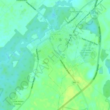
Name: Snow Hill topographic map, elevation, terrain.
Location: Snow Hill, Worcester County, Maryland, United States (38.15085 -75.40553 38.18877 -75.37540)
Average elevation: 7 m
Minimum elevation: -1 m
Maximum elevation: 15 m
Make a donation
Gear up for your next adventure:
As an Amazon Associate, this site earns from qualifying purchases at no extra cost to you.
Other topographic maps
Click on a map to view its topography, its elevation and its terrain.