Geolocate

Lennec topographic map

Click on the map to display elevation.

About this map

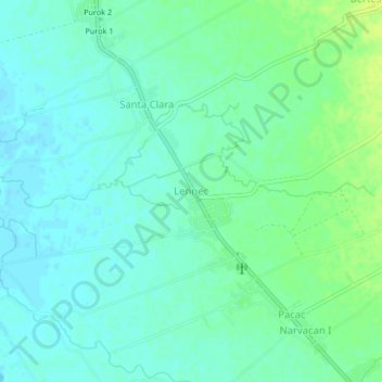
Name: Lennec topographic map, elevation, terrain.

Location: Lennec, Nueva Ecija, Central Luzon, Philippines (15.67836 120.70099 15.71836 120.74099)

Average elevation: 31 m

Minimum elevation: 25 m

Maximum elevation: 41 m

Other topographic maps

Click on a map to view its topography, its elevation and its terrain.

Cuyapo

Philippines > Nueva Ecija

Average elevation: 41 m

Peñaranda

Philippines > Nueva Ecija

Average elevation: 39 m

Aliaga

Philippines > Nueva Ecija

Average elevation: 26 m

Quezon

Philippines > Nueva Ecija

Average elevation: 28 m

Gear up for your next adventure:

🧢Thermal Beanie Hats - Prevent heat loss from the head in windy summit conditions
Lightweight Solo Tents - Backpacking tents designed for wild camping in the UK highlands
🐕Hiking Dog Harnesses - Rugged harnesses for taking your companion on mountain trails
🚲Bikepacking Frame Bags - Storage for tools and navigation gear on long off-road rides
🍱Food Containers - Reusable containers for outdoor meals

As an Amazon Associate, this site earns from qualifying purchases at no extra cost to you.