
gmina Popów topographic map
Interactive map
Click on the map to display elevation.
About this map
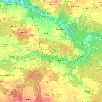
Name: gmina Popów topographic map, elevation, terrain.
Average elevation: 212 m
Minimum elevation: 172 m
Maximum elevation: 255 m
Other topographic maps
Click on a map to view its topography, its elevation and its terrain.
gmina Miedźno
Poland > Silesian Voivodeship > Kłobuck County
gmina Miedźno, Kłobuck County, Silesian Voivodeship, Poland
Average elevation: 220 m
Przedmieście
Poland > Silesian Voivodeship > Kłobuck County > Zawady
Przedmieście, Zawady, gmina Popów, Kłobuck County, Silesian Voivodeship, 42-110, Poland
Average elevation: 212 m
Zbory
Poland > Silesian Voivodeship > Kłobuck County
Zbory, gmina Popów, Kłobuck County, Silesian Voivodeship, 42-110, Poland
Average elevation: 212 m