
Niederdorf topographic map
Interactive map
Click on the map to display elevation.
About this map
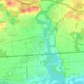
Name: Niederdorf topographic map, elevation, terrain.
Average elevation: 427 m
Minimum elevation: 400 m
Maximum elevation: 468 m
Other topographic maps
Click on a map to view its topography, its elevation and its terrain.
Bannwald
Autriche > Carinthie > Bezirk Klagenfurt-Land > Pörtschach am Wörther See
Bannwald, Pörtschach am Wörther See, Bezirk Klagenfurt-Land, Carinthie, 9210, Autriche
Average elevation: 541 m
Karnburg
Autriche > Carinthie > Bezirk Klagenfurt-Land > Karnburg
Karnburg, Maria Saal, Bezirk Klagenfurt-Land, Carinthie, 9063, Autriche
Average elevation: 540 m
Hochstuhl / Stol
Autriche > Carinthie > Bezirk Klagenfurt-Land > Feistritz im Rosental
Hochstuhl / Stol, Feistritz im Rosental, Bezirk Klagenfurt-Land, Carinthie, Autriche
Average elevation: 1,690 m