
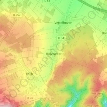
Holzweiler topographic map
Interactive map
Click on the map to display elevation.
About this map
Name: Holzweiler topographic map, elevation, terrain.
Average elevation: 256 m
Minimum elevation: 150 m
Maximum elevation: 350 m
Other topographic maps
Click on a map to view its topography, its elevation and its terrain.
Vettelhoven
Deutschland > Rheinland-Pfalz > Landkreis Ahrweiler > Grafschaft
Vettelhoven, Grafschaft, Landkreis Ahrweiler, Rheinland-Pfalz, 53507, Deutschland
Average elevation: 242 m
Gelsdorf
Deutschland > Rheinland-Pfalz > Landkreis Ahrweiler > Grafschaft
Gelsdorf, Grafschaft, Landkreis Ahrweiler, Rheinland-Pfalz, 53340, Deutschland
Average elevation: 223 m
Bölingen
Deutschland > Rheinland-Pfalz > Landkreis Ahrweiler > Grafschaft > Bölingen
Bölingen, Grafschaft, Landkreis Ahrweiler, Rheinland-Pfalz, 53501, Deutschland
Average elevation: 226 m