
Gryżewo topographic map
Interactive map
Click on the map to display elevation.
About this map
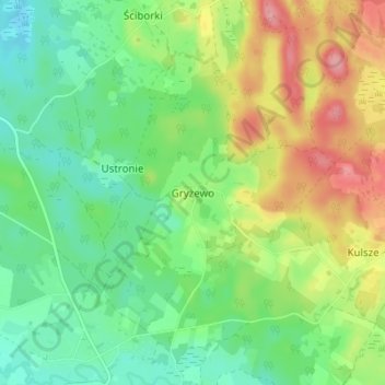
Name: Gryżewo topographic map, elevation, terrain.
Average elevation: 130 m
Minimum elevation: 90 m
Maximum elevation: 196 m
Other topographic maps
Click on a map to view its topography, its elevation and its terrain.
Markowo
Poland > Warmian-Masurian Voivodeship > Gołdap County
Markowo, gmina Dubeninki, Gołdap County, Warmian-Masurian Voivodeship, Poland
Average elevation: 200 m
Gołdap
Poland > Warmian-Masurian Voivodeship > Gołdap County
Gołdap, gmina Gołdap, Gołdap County, Warmian-Masurian Voivodeship, 19-500, Poland
Average elevation: 167 m