
Make a donation
Gear up for your next adventure:
As an Amazon Associate, this site earns from qualifying purchases at no extra cost to you.
Sibuyan Island topographic map
Click on the map to display elevation.
Make a donation
Gear up for your next adventure:
As an Amazon Associate, this site earns from qualifying purchases at no extra cost to you.
Sibuyan Island
Sibuyan is a crescent-shaped island, the second largest in an archipelago comprising Romblon Province, Philippines. Located in the namesake Sibuyan Sea, it has an area of 445 square kilometres (172 sq mi) and has a total population of 62,815, as of the 2020 census. The island has two prominent peaks, the highest is Mount Guiting-Guiting, with an elevation of 2,058 metres (6,752 ft), followed by Mount Nailog, which is 789 metres (2,589 ft) high. The people speak the Sibuyanon dialect of Romblomanon, a Visayan language.
Make a donation
Gear up for your next adventure:
As an Amazon Associate, this site earns from qualifying purchases at no extra cost to you.
About this map
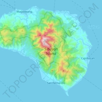
Name: Sibuyan Island topographic map, elevation, terrain.
Location: Sibuyan Island, Romblon, Mimaropa, Philippines (12.26705 122.42342 12.50612 122.69900)
Average elevation: 182 m
Minimum elevation: -1 m
Maximum elevation: 1,991 m
Make a donation
Gear up for your next adventure:
As an Amazon Associate, this site earns from qualifying purchases at no extra cost to you.
Other topographic maps
Click on a map to view its topography, its elevation and its terrain.