
West Dean topographic map
Interactive map
Click on the map to display elevation.
About this map
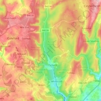
Name: West Dean topographic map, elevation, terrain.
Average elevation: 151 m
Minimum elevation: 25 m
Maximum elevation: 266 m
Other topographic maps
Click on a map to view its topography, its elevation and its terrain.
Cinderford
United Kingdom > England > Forest of Dean > Cinderford
Cinderford, Forest of Dean, Gloucestershire, South West England, England, GL14, United Kingdom
Average elevation: 145 m
Drybrook
United Kingdom > England > Forest of Dean
Drybrook, Forest of Dean, Gloucestershire, South West England, England, United Kingdom
Average elevation: 210 m
Redmarley D'Abitot
United Kingdom > England > Forest of Dean
Redmarley D'Abitot, Forest of Dean, Gloucestershire, South West England, England, United Kingdom
Average elevation: 46 m
Pauntley
United Kingdom > England > Forest of Dean > Pauntley
Pauntley, Forest of Dean, Gloucestershire, South West England, England, GL19 3JA, United Kingdom
Average elevation: 46 m
Ruspidge and Soudley
United Kingdom > England > Forest of Dean
Ruspidge and Soudley, Forest of Dean, Gloucestershire, South West England, England, United Kingdom
Average elevation: 152 m