
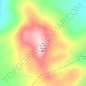
Mount Kempt topographic map
Interactive map
Click on the map to display elevation.
About this map
Name: Mount Kempt topographic map, elevation, terrain.
Average elevation: 1,166 m
Minimum elevation: 905 m
Maximum elevation: 1,419 m
Other topographic maps
Click on a map to view its topography, its elevation and its terrain.
Great Kei River
RSA > Eastern Cape > Amahlathi Local Municipality
Great Kei River, Amahlathi Local Municipality, Amathole District Municipality, Eastern Cape, RSA
Average elevation: 620 m
Kubusi
RSA > Eastern Cape > Amahlathi Local Municipality
Kubusi, Amahlathi Local Municipality, Amathole District Municipality, Eastern Cape, RSA
Average elevation: 1,397 m
Waterdown Dam
RSA > Eastern Cape > Amahlathi Local Municipality
Waterdown Dam, R67, Amahlathi Ward 4, Amahlathi Local Municipality, Amathole District Municipality, Eastern Cape, RSA
Average elevation: 1,269 m