
Thank you for supporting this site ❤️
Make a donation
Make a donation
Gear up for your next adventure:
As an Amazon Associate, this site earns from qualifying purchases at no extra cost to you.
Thabeikkyin Township topographic map
Click on the map to display elevation.
Thank you for supporting this site ❤️
Make a donation
Make a donation
Gear up for your next adventure:
As an Amazon Associate, this site earns from qualifying purchases at no extra cost to you.
About this map
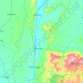
Name: Thabeikkyin Township topographic map, elevation, terrain.
Location: Thabeikkyin Township, Pyin Oo Lwin District, Mandalay, Myanmar (22.69870 95.90287 23.68381 96.39256)
Average elevation: 316 m
Minimum elevation: 69 m
Maximum elevation: 2,201 m
Thank you for supporting this site ❤️
Make a donation
Make a donation
Gear up for your next adventure:
As an Amazon Associate, this site earns from qualifying purchases at no extra cost to you.