Geolocate

Preston topographic map

Click on the map to display elevation.

About this map

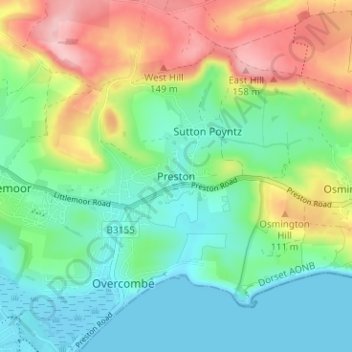
Name: Preston topographic map, elevation, terrain.

Location: Preston, Weymouth, Dorset, England, DT3 6DP, United Kingdom (50.62756 -2.44160 50.66756 -2.40160)

Average elevation: 55 m

Minimum elevation: -1 m

Maximum elevation: 162 m

Dorset trails, hiking, mountain biking, running and outdoor activities

Other topographic maps

Click on a map to view its topography, its elevation and its terrain.

Weymouth Bay

United Kingdom > England > Dorset > Weymouth > Preston

Average elevation: 3 m

Gear up for your next adventure:

🧺Ultralight Dry Bags - Organize and waterproof your gear inside your rucksack
🌦️Portable Weather Meters - Handheld tools for monitoring weather conditions
🧤Hiking Gloves - Warm and durable gloves for cold-weather walks
📷Outdoor Action Cameras - Cameras designed for hiking and adventure
🔋Lithium AA Batteries - Long-lasting power that performs well in cold mountain weather

As an Amazon Associate, this site earns from qualifying purchases at no extra cost to you.