
Westerwald topographic map
Click on the map to display elevation.
Westerwald
The Westerwald (German pronunciation: ; literally 'Western forest') is a low mountain range on the right bank of the river Rhine in the German federal states of Rhineland-Palatinate, Hesse and North Rhine-Westphalia. It is a part of the Rhenish Massif (Rheinisches Schiefergebirge or Rhenish Slate Mountains). Its highest elevation, at 657 m above sea level, is the Fuchskaute in the High Westerwald.
About this map
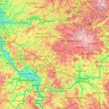
Name: Westerwald topographic map, elevation, terrain.
Location: Westerwald, Rhineland-Palatinate, Germany (50.30275 7.21003 50.81162 8.36354)
Average elevation: 290 m
Minimum elevation: 52 m
Maximum elevation: 686 m
Other topographic maps
Click on a map to view its topography, its elevation and its terrain.
Eifel
Germany > Rhineland-Palatinate > Landkreis Ahrweiler > Adenau
The Eifel is in the Atlantic climate zone with its relatively high precipitation; winters that are moderately cold and long with periods of snow; and summers that are often humid and cool. The prevailing wind is west/southwest. A relatively dry and milder climate prevails in the wind and rain shadow of the…
Average elevation: 585 m
Air Base
Germany > Rhineland-Palatinate > Landkreis Kaiserslautern > Ramstein-Miesenbach
Average elevation: 237 m
Eltz Castle
Germany > Rhineland-Palatinate > Landkreis Mayen-Koblenz > Wierschem
Average elevation: 219 m
Rhine Gorge
Germany > Rhineland-Palatinate > Rhein-Hunsrück-Kreis > Sankt Goar > Biebernheim
Average elevation: 177 m
Eifel
Germany > Rhineland-Palatinate > Landkreis Ahrweiler > Adenau
The Eifel is in the Atlantic climate zone with its relatively high precipitation; winters that are moderately cold and long with periods of snow; and summers that are often humid and cool. The prevailing wind is west/southwest. A relatively dry and milder climate prevails in the wind and rain shadow of the…
Average elevation: 585 m
Monbijou
Germany > Rhineland-Palatinate > Südwestpfalz > Dietrichingen > Monbijou
Average elevation: 302 m
Hallenbad Idar-Oberstein
Germany > Rhineland-Palatinate > Landkreis Birkenfeld > Idar-Oberstein
Average elevation: 343 m
Wingendorf
Germany > Rhineland-Palatinate > Landkreis Altenkirchen (Westerwald)
Average elevation: 285 m
Rhine Gorge
Germany > Rhineland-Palatinate > Rhein-Hunsrück-Kreis > Sankt Goar > Biebernheim
Average elevation: 177 m
Waldfischbach
Germany > Rhineland-Palatinate > Südwestpfalz > Waldfischbach-Burgalben
Average elevation: 326 m
Hinterhausen
Germany > Rhineland-Palatinate > Landkreis Vulkaneifel > Gerolstein
Average elevation: 455 m
Moselhöhe Ediger-Eller
Germany > Rhineland-Palatinate > Landkreis Cochem-Zell > Ediger-Eller
Average elevation: 285 m
Weiperath
Germany > Rhineland-Palatinate > Landkreis Bernkastel-Wittlich > Morbach
The municipality lies at an elevation of between 430 and 770 m above sea level in the low mountain range of the Hunsrück on the boundary with the Birkenfeld district, roughly 25 km southeast of Wittlich and 35 km east of Trier. Its population is 11,051. The nearest town is Bernkastel-Kues.
Average elevation: 439 m
Erbel
Germany > Rhineland-Palatinate > Landkreis Altenkirchen (Westerwald) > Fluterschen
Average elevation: 281 m
Heldberg
Germany > Rhineland-Palatinate > Landkreis Trier-Saarburg > Klüsserath
Average elevation: 215 m
Katz Castle
Germany > Rhineland-Palatinate > Rhein-Lahn-Kreis > Sankt Goarshausen > Heide
Average elevation: 178 m
Eifel
Germany > Rhineland-Palatinate > Landkreis Ahrweiler > Adenau
The Eifel is in the Atlantic climate zone with its relatively high precipitation; winters that are moderately cold and long with periods of snow; and summers that are often humid and cool. The prevailing wind is west/southwest. A relatively dry and milder climate prevails in the wind and rain shadow of the…
Average elevation: 585 m
Der Auborn
Germany > Rhineland-Palatinate > Landkreis Südliche Weinstraße > Schweighofen
Average elevation: 155 m
Wolf
Germany > Rhineland-Palatinate > Landkreis Bernkastel-Wittlich > Traben-Trarbach
Average elevation: 201 m
Schönenberg
Germany > Rhineland-Palatinate > Landkreis Kusel > Schönenberg-Kübelberg
Average elevation: 266 m
Berwartstein
Germany > Rhineland-Palatinate > Südwestpfalz > Erlenbach bei Dahn
Average elevation: 278 m
Dünebusch
Germany > Rhineland-Palatinate > Landkreis Altenkirchen (Westerwald) > Bitzen
Average elevation: 206 m
Wittlich
Germany > Rhineland-Palatinate > Landkreis Bernkastel-Wittlich > Wittlich
Average elevation: 237 m
Brunnel
Germany > Rhineland-Palatinate > Landkreis Südliche Weinstraße > Steinfeld (Pfalz)
Average elevation: 140 m
Haubendell
Germany > Rhineland-Palatinate > Eifelkreis Bitburg-Prüm > Karlshausen > Haubendell
Average elevation: 451 m
Eulenbis
Germany > Rhineland-Palatinate > Landkreis Kaiserslautern > Eulenbis > Eulenbis
Average elevation: 303 m
Ferres
Germany > Rhineland-Palatinate > Landkreis Bernkastel-Wittlich > Piesport > Ferres
Average elevation: 261 m
Berghausen
Germany > Rhineland-Palatinate > Rhein-Lahn-Kreis > Berghausen > Berghausen
Average elevation: 336 m
Miesenheim
Germany > Rhineland-Palatinate > Landkreis Mayen-Koblenz > Andernach
Average elevation: 120 m
Pellenberg
Germany > Rhineland-Palatinate > Landkreis Trier-Saarburg > Merzkirchen
Average elevation: 347 m