
Make a donation
Gear up for your next adventure:
As an Amazon Associate, this site earns from qualifying purchases at no extra cost to you.
Danbury topographic map
Click on the map to display elevation.
Make a donation
Gear up for your next adventure:
As an Amazon Associate, this site earns from qualifying purchases at no extra cost to you.
Danbury
According to the United States Census Bureau, Danbury has a total area of 44.3 square miles (115 km2), of which 42.1 square miles (109 km2) is land and 2.2 square miles (5.7 km2), or 4.94%, is water. The city is located in the foothills of the Berkshire Mountains on low-lying land just south of Candlewood Lake (the City includes the southern parts of the lake). It developed along the Still River, which flows generally from west to east through the city before joining the Housatonic River. The city's terrain includes rolling hills and not-very-tall mountains to the west and northwest called the Western Highland. Ground elevations in the city range from 378 feet to 1,050 feet above sea level.
Make a donation
Gear up for your next adventure:
As an Amazon Associate, this site earns from qualifying purchases at no extra cost to you.
About this map
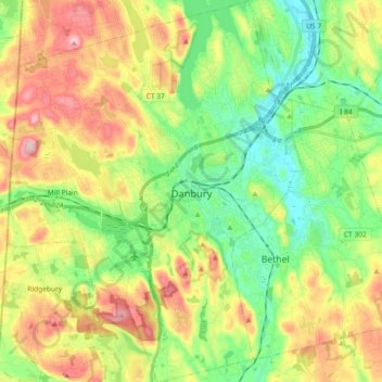
Name: Danbury topographic map, elevation, terrain.
Average elevation: 174 m
Minimum elevation: 77 m
Maximum elevation: 320 m
Make a donation
Gear up for your next adventure:
As an Amazon Associate, this site earns from qualifying purchases at no extra cost to you.
Other topographic maps
Click on a map to view its topography, its elevation and its terrain.
Old Greenwich
United States > Connecticut > Western Connecticut Planning Region > Greenwich
Average elevation: 12 m
Sandy Hook
United States > Connecticut > Western Connecticut Planning Region > Newtown
Average elevation: 113 m
Candlewood Lake Club
United States > Connecticut > Western Connecticut Planning Region > New Milford
Average elevation: 143 m
Cannondale
United States > Connecticut > Western Connecticut Planning Region > Wilton
Average elevation: 110 m
Make a donation
Gear up for your next adventure:
As an Amazon Associate, this site earns from qualifying purchases at no extra cost to you.
Taylor Corners
United States > Connecticut > Western Connecticut Planning Region > New Fairfield
Average elevation: 226 m
Mianus
United States > Connecticut > Western Connecticut Planning Region > Greenwich
Average elevation: 23 m
Winnipauk
United States > Connecticut > Western Connecticut Planning Region > Norwalk
Average elevation: 51 m
West Norwalk
United States > Connecticut > Western Connecticut Planning Region > Norwalk
Average elevation: 50 m
Make a donation
Gear up for your next adventure:
As an Amazon Associate, this site earns from qualifying purchases at no extra cost to you.
Godfrey Corner
United States > Connecticut > Western Connecticut Planning Region > Weston
Average elevation: 110 m
North Mianus
United States > Connecticut > Western Connecticut Planning Region > Greenwich
Average elevation: 32 m
Saugatuck
United States > Connecticut > Western Connecticut Planning Region > Westport
Average elevation: 15 m
Five Points
United States > Connecticut > Western Connecticut Planning Region > Redding Ridge
Average elevation: 185 m
Make a donation
Gear up for your next adventure:
As an Amazon Associate, this site earns from qualifying purchases at no extra cost to you.
Daniels Mill
United States > Connecticut > Western Connecticut Planning Region > New Canaan
Average elevation: 100 m
Thomas Mountain
United States > Connecticut > Western Connecticut Planning Region > Danbury
Average elevation: 197 m
Germantown
United States > Connecticut > Western Connecticut Planning Region > Danbury
Average elevation: 121 m
King Street
United States > Connecticut > Western Connecticut Planning Region > Danbury
Average elevation: 237 m
Make a donation
Gear up for your next adventure:
As an Amazon Associate, this site earns from qualifying purchases at no extra cost to you.
Pinneys Corners
United States > Connecticut > Western Connecticut Planning Region > New Canaan
Average elevation: 143 m
Riverside
United States > Connecticut > Western Connecticut Planning Region > Greenwich > Old Greenwich
Average elevation: 13 m
Beaver Brook
United States > Connecticut > Western Connecticut Planning Region > Danbury
Average elevation: 119 m
King Street
United States > Connecticut > Western Connecticut Planning Region > Danbury
Average elevation: 237 m
Make a donation
Gear up for your next adventure:
As an Amazon Associate, this site earns from qualifying purchases at no extra cost to you.
North Stamford
United States > Connecticut > Western Connecticut Planning Region > Stamford
Average elevation: 89 m
Mianus
United States > Connecticut > Western Connecticut Planning Region > Greenwich
Average elevation: 23 m
Five Points
United States > Connecticut > Western Connecticut Planning Region > Redding Ridge
Average elevation: 185 m
Ponus
United States > Connecticut > Western Connecticut Planning Region > New Canaan
Average elevation: 77 m
Make a donation
Gear up for your next adventure:
As an Amazon Associate, this site earns from qualifying purchases at no extra cost to you.
Great Plain
United States > Connecticut > Western Connecticut Planning Region > Danbury
Average elevation: 132 m
Byram
United States > Connecticut > Western Connecticut Planning Region > Greenwich
Average elevation: 19 m
Wataba Lake
United States > Connecticut > Western Connecticut Planning Region > Ridgefield
Average elevation: 205 m
Tokeneke
United States > Connecticut > Western Connecticut Planning Region > Darien
Average elevation: 14 m
Make a donation
Gear up for your next adventure:
As an Amazon Associate, this site earns from qualifying purchases at no extra cost to you.
Roxbury
United States > Connecticut > Western Connecticut Planning Region > Stamford
Average elevation: 48 m
Deer Hill
United States > Connecticut > Western Connecticut Planning Region > Danbury
Average elevation: 135 m
Long Ridge
United States > Connecticut > Western Connecticut Planning Region > Stamford
Average elevation: 126 m
King Street
United States > Connecticut > Western Connecticut Planning Region > Danbury
Average elevation: 237 m
Make a donation
Gear up for your next adventure:
As an Amazon Associate, this site earns from qualifying purchases at no extra cost to you.
Northfield
United States > Connecticut > Western Connecticut Planning Region > Stamford
Average elevation: 25 m
Town Open Space (Ashford Lane)
United States > Connecticut > Western Connecticut Planning Region > Newtown
Average elevation: 200 m
South End
United States > Connecticut > Western Connecticut Planning Region > Stamford
Average elevation: 11 m
Godfrey Corner
United States > Connecticut > Western Connecticut Planning Region > Weston
Average elevation: 110 m
Make a donation
Gear up for your next adventure:
As an Amazon Associate, this site earns from qualifying purchases at no extra cost to you.
Bold Rock
United States > Connecticut > Western Connecticut Planning Region > Darien
Average elevation: 58 m
Mill River Park
United States > Connecticut > Western Connecticut Planning Region > Stamford
Average elevation: 18 m
Wildmans Landing
United States > Connecticut > Western Connecticut Planning Region > Danbury
Average elevation: 156 m
Chimney Point
United States > Connecticut > Western Connecticut Planning Region > New Milford
Average elevation: 142 m
Make a donation
Gear up for your next adventure:
As an Amazon Associate, this site earns from qualifying purchases at no extra cost to you.
Palestine
United States > Connecticut > Western Connecticut Planning Region > Newtown
Average elevation: 184 m
Beckettville
United States > Connecticut > Western Connecticut Planning Region > Danbury
Average elevation: 155 m
Taylor Corners
United States > Connecticut > Western Connecticut Planning Region > New Fairfield
Average elevation: 226 m
Contentment Island
United States > Connecticut > Western Connecticut Planning Region > Darien
Average elevation: 63 m
Make a donation
Gear up for your next adventure:
As an Amazon Associate, this site earns from qualifying purchases at no extra cost to you.
Belltown
United States > Connecticut > Western Connecticut Planning Region > Stamford
Average elevation: 32 m
Palmers Hill
United States > Connecticut > Western Connecticut Planning Region > Stamford
Average elevation: 31 m
Glenville
United States > Connecticut > Western Connecticut Planning Region > Greenwich
Average elevation: 54 m
Turn of River
United States > Connecticut > Western Connecticut Planning Region > Stamford
Average elevation: 58 m
Make a donation
Gear up for your next adventure:
As an Amazon Associate, this site earns from qualifying purchases at no extra cost to you.
Riverbank
United States > Connecticut > Western Connecticut Planning Region > Stamford
Average elevation: 72 m
Honey Hill
United States > Connecticut > Western Connecticut Planning Region > Wilton
Average elevation: 126 m
Riverside
United States > Connecticut > Western Connecticut Planning Region > Greenwich > Old Greenwich
Average elevation: 13 m
Candlewood Springs
United States > Connecticut > Western Connecticut Planning Region > New Milford
Average elevation: 146 m
Make a donation
Gear up for your next adventure:
As an Amazon Associate, this site earns from qualifying purchases at no extra cost to you.
Candlewood Orchards
United States > Connecticut > Western Connecticut Planning Region > Brookfield
Average elevation: 141 m