
Make a donation
Gear up for your next adventure:
As an Amazon Associate, this site earns from qualifying purchases at no extra cost to you.
42000 topographic map
Click on the map to display elevation.
Make a donation
Gear up for your next adventure:
As an Amazon Associate, this site earns from qualifying purchases at no extra cost to you.
About this map
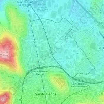
Name: 42000 topographic map, elevation, terrain.
Average elevation: 518 m
Minimum elevation: 475 m
Maximum elevation: 642 m
Make a donation
Gear up for your next adventure:
As an Amazon Associate, this site earns from qualifying purchases at no extra cost to you.
Other topographic maps
Click on a map to view its topography, its elevation and its terrain.
Saint-Étienne
France > Auvergne-Rhône-Alpes > Loire > Saint-Étienne
La superficie de la commune est de 79,97 km2 ; son altitude varie de 422 à 1 177 mètres.
Average elevation: 662 m
Make a donation
Gear up for your next adventure:
As an Amazon Associate, this site earns from qualifying purchases at no extra cost to you.
Au Martinet Neuf
France > Auvergne-Rhône-Alpes > Loire > Saint-Étienne > Rochetaillée
Average elevation: 839 m
Château de la Perrotière
France > Auvergne-Rhône-Alpes > Loire > Saint-Étienne
Average elevation: 613 m
Make a donation
Gear up for your next adventure:
As an Amazon Associate, this site earns from qualifying purchases at no extra cost to you.
Font Mora
France > Auvergne-Rhône-Alpes > Loire > Saint-Étienne > Rochetaillée
Average elevation: 932 m
Au Besson
France > Auvergne-Rhône-Alpes > Loire > Saint-Étienne > Rochetaillée
Average elevation: 754 m
Make a donation
Gear up for your next adventure:
As an Amazon Associate, this site earns from qualifying purchases at no extra cost to you.
La Maison Blanche
France > Auvergne-Rhône-Alpes > Loire > Saint-Étienne > Rochetaillée
Average elevation: 835 m
La Rouère
France > Auvergne-Rhône-Alpes > Loire > Saint-Étienne > Rochetaillée
Average elevation: 816 m
Grotte de Rochecorbière
France > Auvergne-Rhône-Alpes > Loire > Saint-Étienne > Rochetaillée > Font Mora
Average elevation: 909 m
Make a donation
Gear up for your next adventure:
As an Amazon Associate, this site earns from qualifying purchases at no extra cost to you.
Le Breuil
France > Auvergne-Rhône-Alpes > Loire > Saint-Étienne > Rochetaillée
Average elevation: 827 m