
Make a donation
Gear up for your next adventure:
As an Amazon Associate, this site earns from qualifying purchases at no extra cost to you.
Amarnath Cave Temple topographic map
Click on the map to display elevation.
Make a donation
Gear up for your next adventure:
As an Amazon Associate, this site earns from qualifying purchases at no extra cost to you.
Amarnath Cave Temple
The Shiva Lingam at the shrine is a Swayambhu lingam. The lingam is a natural stalagmite formation located at the Amarnath Mountain which has a peak of 5,186 metres (17,014 ft), and inside a 40 m (130 ft) high cave at an elevation of 3,888 m (12,756 ft). The stalagmite is formed due to the freezing of water drops that fall from the roof of the cave onto the floor resulting in an upward vertical growth of ice. There are different types of stalagmites. Here, the stalagmites considered as the lingam, a physical manifestation of Shiva, form a solid-dome-shape. Parvati and Ganesha are also present here as two smaller stalagmites.
Make a donation
Gear up for your next adventure:
As an Amazon Associate, this site earns from qualifying purchases at no extra cost to you.
About this map
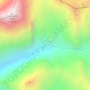
Name: Amarnath Cave Temple topographic map, elevation, terrain.
Average elevation: 4,325 m
Minimum elevation: 3,719 m
Maximum elevation: 5,200 m
Make a donation
Gear up for your next adventure:
As an Amazon Associate, this site earns from qualifying purchases at no extra cost to you.
Other topographic maps
Click on a map to view its topography, its elevation and its terrain.