
San Antonio topographic map
Interactive map
Click on the map to display elevation.
About this map
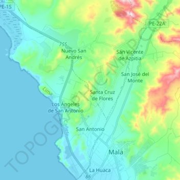
Name: San Antonio topographic map, elevation, terrain.
Location: San Antonio, Province of Cañete, Lima, Peru (-12.67637 -76.72625 -12.55568 -76.63861)
Average elevation: 128 m
Minimum elevation: -1 m
Maximum elevation: 667 m
Other topographic maps
Click on a map to view its topography, its elevation and its terrain.
Playa León Dormido
Peru > Lima > San Antonio
Playa León Dormido, Carretera Panamericana Sur, Condominio Costa del Campo, San Antonio, Cañete, Lima, Peru
Average elevation: 51 m