
Dry Can Creek topographic map
Interactive map
Click on the map to display elevation.
About this map
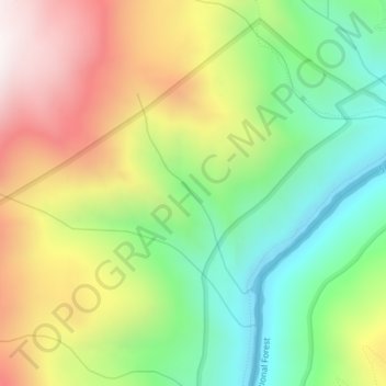
Name: Dry Can Creek topographic map, elevation, terrain.
Location: Dry Can Creek, Idaho County, Idaho, United States (45.51696 -115.33426 45.53097 -115.32225)
Average elevation: 1,163 m
Minimum elevation: 722 m
Maximum elevation: 1,748 m
Other topographic maps
Click on a map to view its topography, its elevation and its terrain.
Nugget Point
United States > Idaho > Idaho County
Nugget Point, Idaho County, Idaho, United States
Average elevation: 1,659 m
Grangeville
United States > Idaho > Idaho County
Grangeville, Idaho County, Idaho, United States
Average elevation: 1,037 m
The Maze
United States > Idaho > Idaho County
The Maze, Idaho County, Idaho, United States
Average elevation: 533 m
Riggins
United States > Idaho > Idaho County
Riggins, Idaho County, Idaho, 83549, United States
Average elevation: 706 m