
Make a donation
Gear up for your next adventure:
As an Amazon Associate, this site earns from qualifying purchases at no extra cost to you.
Ureterp topographic map
Click on the map to display elevation.
Make a donation
Gear up for your next adventure:
As an Amazon Associate, this site earns from qualifying purchases at no extra cost to you.
Ureterp
In 1641 sloot de Haagse koopman Passchier Bolleman met de bewoners van Noorder- en Suider-Drachten een contract om ten behoeve van de veenafgraving een vaart te graven vanaf Buitenvallaat. Deze vaart werd tussen 1657 en 1667 doorgegraven vanaf het Vallaat naar Frieschepalen en werd hier bekend als de Ureterpervaart. Bij het Vallaat kwam een schutsluis (ook wel vallaat genoemd) om het hoogteverschil te overbruggen. Hier stond van 1899 tot 1911 ook een zuivelfabriekje op de afslag van de weg naar Ureterp (net ten westen van de huidige Opperhaudmare). In 1938 werd de vaart omgelegd ten behoeve van een vaste stenen brug, die daar over de vaart kwam. Deze brug verdween al na 30 jaar, om plaats te maken voor de huidige Opperhaudmare en bijbehorende viaducten.
Make a donation
Gear up for your next adventure:
As an Amazon Associate, this site earns from qualifying purchases at no extra cost to you.
About this map
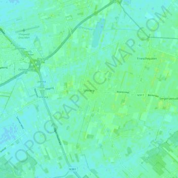
Name: Ureterp topographic map, elevation, terrain.
Location: Ureterp, Opsterland, Fryslân, Nederland (53.06299 6.10961 53.12921 6.19736)
Average elevation: 4 m
Minimum elevation: -1 m
Maximum elevation: 9 m
Make a donation
Gear up for your next adventure:
As an Amazon Associate, this site earns from qualifying purchases at no extra cost to you.
Other topographic maps
Click on a map to view its topography, its elevation and its terrain.
Make a donation
Gear up for your next adventure:
As an Amazon Associate, this site earns from qualifying purchases at no extra cost to you.
Make a donation
Gear up for your next adventure:
As an Amazon Associate, this site earns from qualifying purchases at no extra cost to you.
Make a donation
Gear up for your next adventure:
As an Amazon Associate, this site earns from qualifying purchases at no extra cost to you.
Laaxum
In 1718 stonden er acht huizen in de buurtschap en in 1851 zes. Aan het begin van de twintigste eeuw was Laaxum een plaats met zestien huizen en twee boerderijen, waarin samen meer dan honderd mensen woonden. In het begin van de eenentwintigste stonden er elf huizen en één boerderij. De haven werd ook wel…
Average elevation: 0 m
Make a donation
Gear up for your next adventure:
As an Amazon Associate, this site earns from qualifying purchases at no extra cost to you.
Make a donation
Gear up for your next adventure:
As an Amazon Associate, this site earns from qualifying purchases at no extra cost to you.
Make a donation
Gear up for your next adventure:
As an Amazon Associate, this site earns from qualifying purchases at no extra cost to you.
Make a donation
Gear up for your next adventure:
As an Amazon Associate, this site earns from qualifying purchases at no extra cost to you.
Make a donation
Gear up for your next adventure:
As an Amazon Associate, this site earns from qualifying purchases at no extra cost to you.
Skilleard
Schillaard werd in 1445 vermeld als Scallaert, in 1478 als Schillaerdt, in 1482 als Schellart en in 16e en 17e eeuw als Schillaerd. De plaatsnaam zou mogelijk verwijzen naar een terp (werth) bij een schelpenbank (skil-schelp). Een andere mogelijke betekenis is dat de terp/wierde scheef weglopend was, waarbij…
Average elevation: 0 m
Make a donation
Gear up for your next adventure:
As an Amazon Associate, this site earns from qualifying purchases at no extra cost to you.