
The Rookery topographic map
Click on the map to display elevation.
About this map
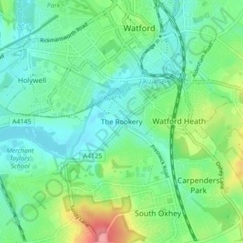
Name: The Rookery topographic map, elevation, terrain.
Average elevation: 72 m
Minimum elevation: 48 m
Maximum elevation: 135 m
Hertfordshire trails, hiking, mountain biking, running and outdoor activities
Other topographic maps
Click on a map to view its topography, its elevation and its terrain.
Croxley Green
United Kingdom > England > Hertfordshire > Three Rivers > Rickmansworth
Average elevation: 67 m
The Rookery
United Kingdom > England > Hertfordshire > Three Rivers > Abbots Langley > Langleybury
Average elevation: 92 m
Oxhey Woods Local Nature Reserve
United Kingdom > England > Hertfordshire > Three Rivers > South Oxhey
Average elevation: 88 m