
Serre Uberto topographic map
Interactive map
Click on the map to display elevation.
About this map
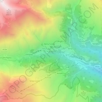
Name: Serre Uberto topographic map, elevation, terrain.
Location: Serre Uberto, Crissolo, Coni, Piémont, Italie (44.68280 7.12321 44.72280 7.16321)
Average elevation: 1,819 m
Minimum elevation: 1,186 m
Maximum elevation: 2,692 m
Other topographic maps
Click on a map to view its topography, its elevation and its terrain.
Pian del Re
Italie > Piémont > Coni > Crissolo
Pian del Re, Crissolo, Coni, Piémont, Italie
Average elevation: 2,380 m
Pian della Regina
Italie > Piémont > Coni > Crissolo
Pian della Regina, Crissolo, Coni, Piémont, Italie
Average elevation: 2,105 m