
Thank you for supporting this site ❤️
Make a donation
Make a donation
Gear up for your next adventure:
As an Amazon Associate, this site earns from qualifying purchases at no extra cost to you.
Incari topographic map
Click on the map to display elevation.
Thank you for supporting this site ❤️
Make a donation
Make a donation
Gear up for your next adventure:
As an Amazon Associate, this site earns from qualifying purchases at no extra cost to you.
About this map
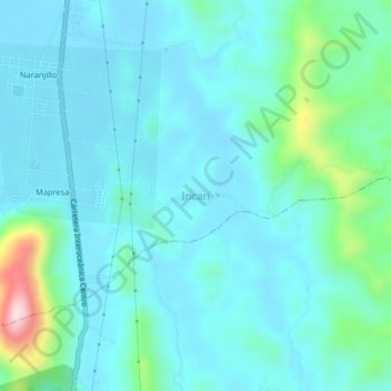
Name: Incari topographic map, elevation, terrain.
Location: Incari, Provincia de Leoncio Prado, Huánuco, Perú (-9.28207 -75.99736 -9.24207 -75.95736)
Average elevation: 681 m
Minimum elevation: 624 m
Maximum elevation: 986 m
Thank you for supporting this site ❤️
Make a donation
Make a donation
Gear up for your next adventure:
As an Amazon Associate, this site earns from qualifying purchases at no extra cost to you.