Geolocate

Moncada topographic map

Click on the map to display elevation.

About this map

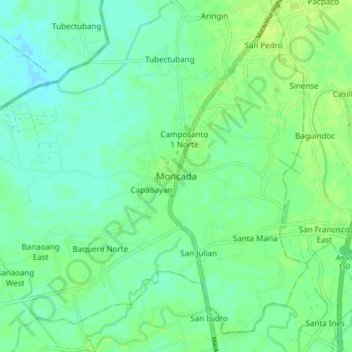
Name: Moncada topographic map, elevation, terrain.

Location: Moncada, Tarlac, Central Luzon, 2308, Philippines (15.69369 120.53270 15.77369 120.61270)

Average elevation: 16 m

Minimum elevation: 10 m

Maximum elevation: 23 m

Gear up for your next adventure:

📸Action Camera Chest Mounts - Record your ascent following topographic paths hands-free
📦Compression Sacks - Reduce backpack volume efficiently
👟Men's Trail Running Shoes - Lightweight grip for fast movement over topographic contours
📱Phone Mounts for Hiking - Secure mounts to carry your phone on trails
🦶Anti-Blister Balms - Protect your feet before long topographic expeditions

As an Amazon Associate, this site earns from qualifying purchases at no extra cost to you.