
Make a donation
Gear up for your next adventure:
As an Amazon Associate, this site earns from qualifying purchases at no extra cost to you.
Kurigram topographic map
Click on the map to display elevation.
Make a donation
Gear up for your next adventure:
As an Amazon Associate, this site earns from qualifying purchases at no extra cost to you.
Kurigram
The town of Kurigram located in the alluvial plain of Teesta-Brahmaputra basin at the bank of Dharla River . The avarage elevation of the town in 31 meter. Kurigram's humid subtropical climate (Köppen Cwa) is influenced by the monsoon and features mild winters and extremely rainy and wet summers. The region surrounding the town is at risk of flooding due to the rivers' overflow during the intense Monsoon rains because of its riverine terrain and relatively low elevation.
Make a donation
Gear up for your next adventure:
As an Amazon Associate, this site earns from qualifying purchases at no extra cost to you.
About this map
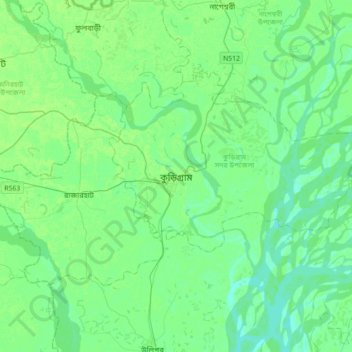
Name: Kurigram topographic map, elevation, terrain.
Average elevation: 27 m
Minimum elevation: 14 m
Maximum elevation: 71 m
Make a donation
Gear up for your next adventure:
As an Amazon Associate, this site earns from qualifying purchases at no extra cost to you.