
Chez Mauxion topographic map
Interactive map
Click on the map to display elevation.
About this map
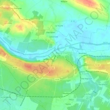
Name: Chez Mauxion topographic map, elevation, terrain.
Average elevation: 26 m
Minimum elevation: 7 m
Maximum elevation: 61 m
Other topographic maps
Click on a map to view its topography, its elevation and its terrain.
Tilloux
France > Nouvelle-Aquitaine > Charente > Bourg-Charente
Tilloux, Bourg-Charente, Cognac, Charente, Nouvelle-Aquitaine, France métropolitaine, 16200, France
Average elevation: 26 m
Veillard
France > Nouvelle-Aquitaine > Charente > Bourg-Charente
Veillard, Bourg-Charente, Cognac, Charente, Nouvelle-Aquitaine, France métropolitaine, 16200, France
Average elevation: 25 m
Lancement
France > Nouvelle-Aquitaine > Charente > Bourg-Charente
Lancement, Bourg-Charente, Cognac, Charente, Nouvelle-Aquitaine, France métropolitaine, 16200, France
Average elevation: 28 m