Geolocate

Cornelia topographic map

Click on the map to display elevation.

About this map

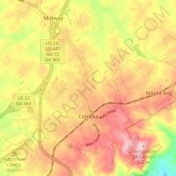
Name: Cornelia topographic map, elevation, terrain.

Location: Cornelia, Habersham County, Georgia, United States (34.49307 -83.55802 34.54719 -83.50212)

Average elevation: 446 m

Minimum elevation: 305 m

Maximum elevation: 544 m

Other topographic maps

Click on a map to view its topography, its elevation and its terrain.

Aerial

United States > Georgia > Habersham County

Average elevation: 450 m

Pardue Mill

United States > Georgia > Habersham County

Average elevation: 413 m

Gear up for your next adventure:

🦯Walking Poles - Supportive poles for long-distance walking
🍱Food Containers - Reusable containers for outdoor meals
📐Altimeters & Barometers - Tools for measuring altitude and air pressure
🧊Insulated Flasks - Keeps drinks hot or cold during hikes
🧤Waterproof Overmitts - Extreme weather protection for hikers and mountaineers

As an Amazon Associate, this site earns from qualifying purchases at no extra cost to you.