

San Francisco topographic map
Click on the map to display elevation.
San Francisco
Because of its sharp topography and maritime influences, San Francisco exhibits a multitude of distinct microclimates. The high hills in the geographic center of the city are responsible for a 20% variance in annual rainfall between different parts of the city. They also protect neighborhoods directly to their east from the foggy and sometimes very cold and windy conditions experienced in the Sunset District; for those who live on the eastern side of the city, San Francisco is sunnier, with an average of 260 clear days, and only 105 cloudy days per year.
About this map
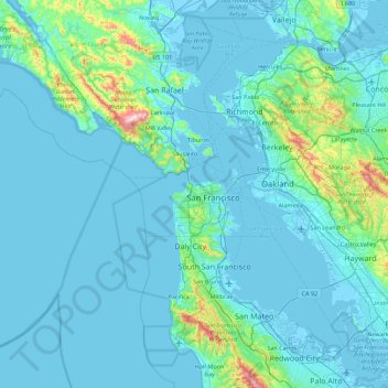
Name: San Francisco topographic map, elevation, terrain.
Location: San Francisco, California, United States of America (37.64031 -123.17383 37.92984 -122.28002)
Average elevation: 57 m
Minimum elevation: -5 m
Maximum elevation: 753 m
Other topographic maps
Click on a map to view its topography, its elevation and its terrain.
Riverside
United States of America > California > Riverside
Riverside is the 59th largest city in the United States, the 12th largest city in California, and the largest city in California's Inland Empire metro area. According to the United States Census Bureau, the city has a total area of 81.4 square miles (210.8 km2), of which 81.1 square miles (210 km2) is land and…
Average elevation: 351 m
Lake Elsinore
United States of America > California > Lake Elsinore
The rainfall until 1893 was greater than normal, and the lake remained high and overflowed naturally on three or four occasions during that time. The lake water was purchased by the Temescal Water Company for the irrigation of land in Corona. Its outlet channel was deepened, permitting gravity flow down the…
Average elevation: 531 m
Beaumont
United States of America > California > Beaumont
Beaumont is a city in Riverside County, California, United States, located at a half-mile elevation in the pass area south of Southern California's highest peak, San Gorgonio Mountain, and north of San Jacinto Peak.
Average elevation: 725 m
Palmdale
United States of America > California > Palmdale
Downtown Palmdale is located at 34°34′46″N 118°07′00″W / 34.57944°N 118.11667°W / 34.57944; -118.11667, at an elevation of 2,655 feet (809 m) above sea level.
Average elevation: 898 m