
Thank you for supporting this site ❤️
Make a donation
Make a donation
Gear up for your next adventure:
As an Amazon Associate, this site earns from qualifying purchases at no extra cost to you.
Dharwad topographic map
Click on the map to display elevation.
Thank you for supporting this site ❤️
Make a donation
Make a donation
Gear up for your next adventure:
As an Amazon Associate, this site earns from qualifying purchases at no extra cost to you.
About this map
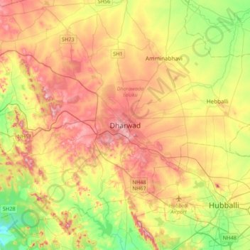
Name: Dharwad topographic map, elevation, terrain.
Location: Dharwad, Dharawada taluku, Dharwad, Karnataka, 580001, India (15.29405 74.84665 15.61405 75.16665)
Average elevation: 656 m
Minimum elevation: 543 m
Maximum elevation: 778 m
Thank you for supporting this site ❤️
Make a donation
Make a donation
Gear up for your next adventure:
As an Amazon Associate, this site earns from qualifying purchases at no extra cost to you.