
Carmen topographic map
Interactive map
Click on the map to display elevation.
About this map
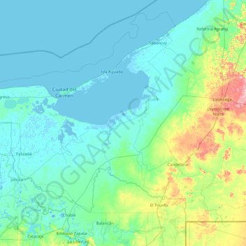
Name: Carmen topographic map, elevation, terrain.
Location: Carmen, Campeche, México (17.87274 -92.46903 19.03233 -90.79543)
Average elevation: 20 m
Minimum elevation: -7 m
Maximum elevation: 174 m
Other topographic maps
Click on a map to view its topography, its elevation and its terrain.
Reserva de la Biosfera Calakmul
Reserva de la Biosfera Calakmul, Campeche, México
Average elevation: 170 m
Curvas de Nivel 30
México > Campeche > Curvas de Nivel 30
Curvas de Nivel 30, Carmen, Campeche, México
Average elevation: 22 m