
Neubeuern topographic map
Interactive map
Click on the map to display elevation.
About this map
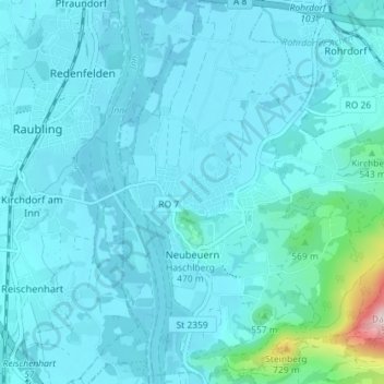
Name: Neubeuern topographic map, elevation, terrain.
Location: Neubeuern, Landkreis Rosenheim, Bavaria, 83115, Germany (47.75711 12.12535 47.80532 12.18647)
Average elevation: 482 m
Minimum elevation: 443 m
Maximum elevation: 890 m
Other topographic maps
Click on a map to view its topography, its elevation and its terrain.
Kolbermoor
Germany > Bavaria > Landkreis Rosenheim
Kolbermoor, Landkreis Rosenheim, Bavaria, 83059, Germany
Average elevation: 467 m
Oberaudorf
Germany > Bavaria > Landkreis Rosenheim
Oberaudorf, Landkreis Rosenheim, Bavaria, 83080, Germany
Average elevation: 792 m
Sachrang
Germany > Bavaria > Landkreis Rosenheim
Sachrang, Aschau im Chiemgau, Landkreis Rosenheim, Bavaria, Germany
Average elevation: 982 m
Aschau im Chiemgau
Germany > Bavaria > Landkreis Rosenheim
Aschau im Chiemgau, Landkreis Rosenheim, Bavaria, 83229, Germany
Average elevation: 957 m