
Hentland topographic map
Interactive map
Click on the map to display elevation.
About this map
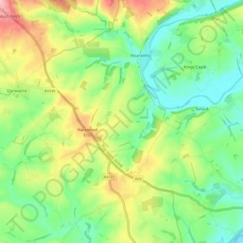
Name: Hentland topographic map, elevation, terrain.
Location: Hentland, Harewood End, Herefordshire, England, United Kingdom (51.90719 -2.69395 51.97594 -2.64377)
Average elevation: 85 m
Minimum elevation: 29 m
Maximum elevation: 177 m
Other topographic maps
Click on a map to view its topography, its elevation and its terrain.
Michaelchurch
United Kingdom > England > Herefordshire > Harewood End
Michaelchurch, Tretire with Michaelchurch, Harewood End, Herefordshire, England, HR2 8LD, United Kingdom
Average elevation: 90 m