
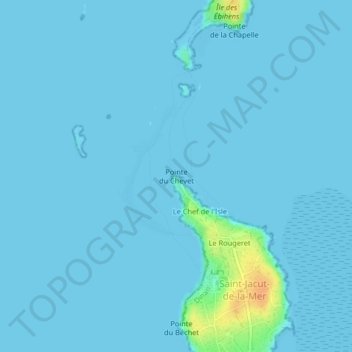
Pointe du Chevet topographic map
Interactive map
Click on the map to display elevation.
About this map
Name: Pointe du Chevet topographic map, elevation, terrain.
Average elevation: 2 m
Minimum elevation: -1 m
Maximum elevation: 34 m
Other topographic maps
Click on a map to view its topography, its elevation and its terrain.
Plage du Rougeret
France > Bretagne > Saint-Jacut-de-la-Mer
Plage du Rougeret, Boulevard du Rougeret, Saint-Jacut-de-la-Mer, Dinan, Côtes-d'Armor, Bretagne, France métropolitaine, 22750, France
Average elevation: 2 m
Île de la Colombière
France > Bretagne > Saint-Jacut-de-la-Mer
Île de la Colombière, Saint-Jacut-de-la-Mer, Dinan, Côtes-d'Armor, Bretagne, France métropolitaine, 22750, France
Average elevation: 0 m