
Bispingen topographic map
Interactive map
Click on the map to display elevation.
About this map
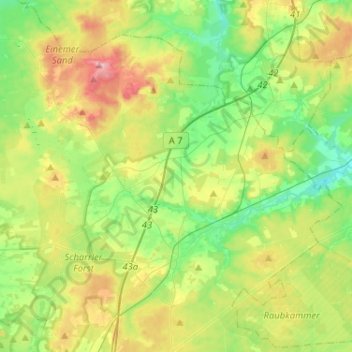
Name: Bispingen topographic map, elevation, terrain.
Location: Bispingen, Heidekreis, Lower Saxony, 29646, Germany (53.05600 9.86038 53.18087 10.11836)
Average elevation: 91 m
Minimum elevation: 47 m
Maximum elevation: 167 m
Other topographic maps
Click on a map to view its topography, its elevation and its terrain.
Bad Fallingbostel
Germany > Lower Saxony > Heidekreis
Bad Fallingbostel, Heidekreis, Lower Saxony, 29683, Germany
Average elevation: 64 m
Walsrode
Germany > Lower Saxony > Heidekreis
Walsrode, Heidekreis, Lower Saxony, Germany
Average elevation: 48 m
Schülern
Germany > Lower Saxony > Heidekreis > Schneverdingen > Schülern
Schülern, Schneverdingen, Heidekreis, Lower Saxony, 29640, Germany
Average elevation: 80 m
Soltau
Germany > Lower Saxony > Heidekreis > Soltau
Soltau, Heidekreis, Lower Saxony, 29614, Germany
Average elevation: 78 m