Geolocate

Bore topographic map

Click on the map to display elevation.

About this map

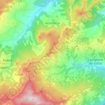
Name: Bore topographic map, elevation, terrain.

Location: Bore, Parma, Emilia-Romagna, 43030, Italy (44.67535 9.76023 44.76219 9.88342)

Average elevation: 678 m

Minimum elevation: 325 m

Maximum elevation: 1,295 m

Gear up for your next adventure:

🎒Hiking Backpacks - Comfortable backpacks for day hikes and multi-day treks
🗺️Topographic Maps - Detailed maps showing elevation and terrain features
🧦Hiking Socks - Breathable socks designed to prevent blisters on long walks
🧗Locking Carabiners - Secure gear to your pack or for light technical use
🛌Sleeping Mats - Insulated mats for comfortable outdoor sleeping

As an Amazon Associate, this site earns from qualifying purchases at no extra cost to you.