
Make a donation
Gear up for your next adventure:
As an Amazon Associate, this site earns from qualifying purchases at no extra cost to you.
Table Rock Mountain topographic map
Click on the map to display elevation.
Make a donation
Gear up for your next adventure:
As an Amazon Associate, this site earns from qualifying purchases at no extra cost to you.
About this map
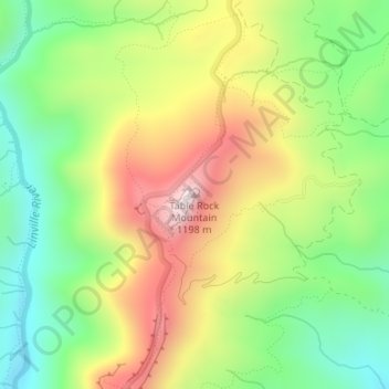
Name: Table Rock Mountain topographic map, elevation, terrain.
Average elevation: 807 m
Minimum elevation: 533 m
Maximum elevation: 1,165 m
Make a donation
Gear up for your next adventure:
As an Amazon Associate, this site earns from qualifying purchases at no extra cost to you.
Other topographic maps
Click on a map to view its topography, its elevation and its terrain.
South Mountains State Park
United States > North Carolina > Burke County
While most of the high points average approximately 2000 feet (609 m) in elevation, Buzzard's Roost towers some 3000 feet (914 m) above the surrounding landscape. Elevations within the park itself range from less than 1200 feet (365 m) at points along Jacob's Fork River to 3,000 feet (914 m) on Buzzard's Roost…
Average elevation: 498 m
Make a donation
Gear up for your next adventure:
As an Amazon Associate, this site earns from qualifying purchases at no extra cost to you.
Lake James
United States > North Carolina > Burke County
Lake James is a large reservoir in the mountains of Western North Carolina which straddles the border between Burke and McDowell Counties. It is named for tobacco tycoon and benefactor of Duke University James Buchanan Duke. The lake, with surface elevation of 1200 ft (366 m), lies behind a series of 4 earthen…
Average elevation: 381 m
Make a donation
Gear up for your next adventure:
As an Amazon Associate, this site earns from qualifying purchases at no extra cost to you.
Lake James
United States > North Carolina > Burke County
Lake James is a large reservoir in the mountains of Western North Carolina which straddles the border between Burke and McDowell Counties. It is named for tobacco tycoon and benefactor of Duke University James Buchanan Duke. The lake, with surface elevation of 1200 ft (366 m), lies behind a series of 3 earthen…
Average elevation: 381 m
Make a donation
Gear up for your next adventure:
As an Amazon Associate, this site earns from qualifying purchases at no extra cost to you.