
Thank you for supporting this site ❤️
Make a donation
Make a donation
Gear up for your next adventure:
As an Amazon Associate, this site earns from qualifying purchases at no extra cost to you.
Englewood topographic map
Click on the map to display elevation.
Thank you for supporting this site ❤️
Make a donation
Make a donation
Gear up for your next adventure:
As an Amazon Associate, this site earns from qualifying purchases at no extra cost to you.
About this map
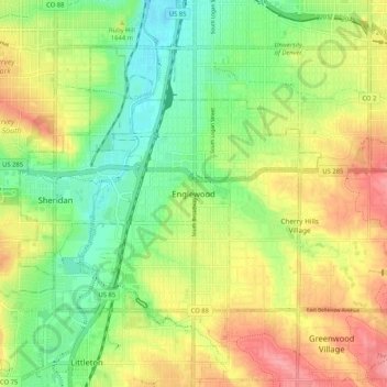
Name: Englewood topographic map, elevation, terrain.
Location: Englewood, Arapahoe County, Colorado, 80110, United States (39.60821 -105.02796 39.68821 -104.94796)
Average elevation: 1,642 m
Minimum elevation: 1,598 m
Maximum elevation: 1,696 m
Thank you for supporting this site ❤️
Make a donation
Make a donation
Gear up for your next adventure:
As an Amazon Associate, this site earns from qualifying purchases at no extra cost to you.