
Kampung Jawa topographic map
Interactive map
Click on the map to display elevation.
About this map
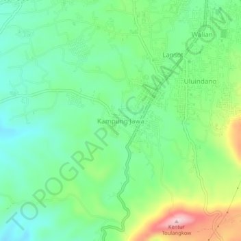
Name: Kampung Jawa topographic map, elevation, terrain.
Location: Kampung Jawa, Tomohon, North Sulawesi, 95439, Indonesia (1.27667 124.80372 1.31667 124.84372)
Average elevation: 767 m
Minimum elevation: 683 m
Maximum elevation: 946 m
Other topographic maps
Click on a map to view its topography, its elevation and its terrain.