
Storrs topographic map
Click on the map to display elevation.
About this map
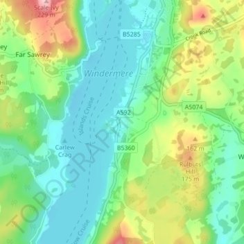
Name: Storrs topographic map, elevation, terrain.
Average elevation: 93 m
Minimum elevation: 36 m
Maximum elevation: 226 m
Cumbria trails, hiking, mountain biking, running and outdoor activities
Other topographic maps
Click on a map to view its topography, its elevation and its terrain.
Windermere
United Kingdom > England > Cumbria > South Lakeland > Bowness-on-Windermere
There is debate as to whether the stretch of water between Newby Bridge and Lakeside at the southern end of the lake should be considered part of Windermere, or a navigable stretch of the River Leven. This affects the stated length of the lake, which is 11.23 miles (18.07 km) long if measured from the bridge…
Average elevation: 132 m