
Harden topographic map
Click on the map to display elevation.
About this map
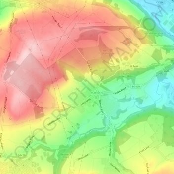
Name: Harden topographic map, elevation, terrain.
Location: Harden, Bradford, West Yorkshire, England, United Kingdom (53.83088 -1.90174 53.85462 -1.84449)
Average elevation: 198 m
Minimum elevation: 79 m
Maximum elevation: 298 m
England trails, hiking, mountain biking, running and outdoor activities
Other topographic maps
Click on a map to view its topography, its elevation and its terrain.
Cackleshaw
United Kingdom > England > Bradford > Keighley > Oakworth > Cackleshaw
Average elevation: 219 m