
Pufendorf topographic map
Interactive map
Click on the map to display elevation.
About this map
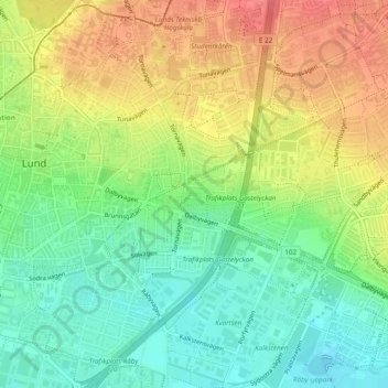
Name: Pufendorf topographic map, elevation, terrain.
Average elevation: 47 m
Minimum elevation: 18 m
Maximum elevation: 80 m
Other topographic maps
Click on a map to view its topography, its elevation and its terrain.
Eleven
Suède > Comté de Scanie > Lund
Eleven, Mårtens fälad, Öster, Lund, Lunds kommun, Comté de Scanie, Suède
Average elevation: 58 m
Leon
Suède > Comté de Scanie > Lund
Leon, Östra Torn, Öster, Lund, Lunds kommun, Comté de Scanie, Suède
Average elevation: 75 m