
La Montée topographic map
Interactive map
Click on the map to display elevation.
About this map
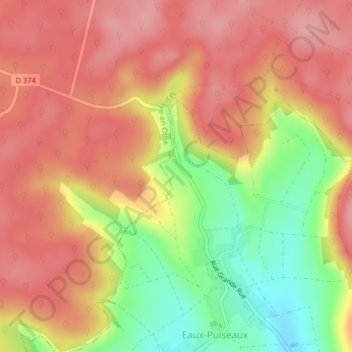
Name: La Montée topographic map, elevation, terrain.
Average elevation: 249 m
Minimum elevation: 175 m
Maximum elevation: 293 m
Other topographic maps
Click on a map to view its topography, its elevation and its terrain.
Hameau des Bordes
France > Grand Est > Aube > Eaux-Puiseaux
Hameau des Bordes, Eaux-Puiseaux, Troyes, Aube, Grand Est, France métropolitaine, 10130, France
Average elevation: 212 m
Hameau d'Eaux
France > Grand Est > Aube > Eaux-Puiseaux
Hameau d'Eaux, Eaux-Puiseaux, Troyes, Aube, Grand Est, France métropolitaine, 10130, France
Average elevation: 231 m